About the project
Shellharbour City Council is reviewing all Alcohol Free Zones (AFZs) and Alcohol Prohibited Areas (APAs) across the city.
These zones help reduce alcohol-related issues in public places and support safer, more welcoming streets, parks and shared spaces.
We’re proposing to:
- Keep some zones the same
- Adjust boundaries in some areas
- Introduce new zones where needed
We’ve worked with NSW Police, reviewed local data and listened to community concerns. Now we’re asking people who live or own property in areas which may be impacted by proposed new or changing zones, to review the proposed changes and share their views before the public exhibition later this year.
FAQ
Proposed locations
We’re seeking feedback on six zones where changes are proposed. These include:
- Existing zones with boundary adjustments
- New zones being proposed for the first time
Each zone has a map and a summary of the proposed changes. Explore the details below, then complete the short survey to share your views.
Existing zones with proposed changes
What’s proposed:
- Re-establish the existing zone
- Extend it to include nearby streets and laneways
Current zone includes:
- Con O’Keefe Park
- Di Gorman Oval
- Bicentennial Park (near Albion Park High School)
- Melaleuca Park
- Russell Street car park and roadway
- Church Street (in front of the high school)
Proposed additions:
- Terry Street (Tongarra Road to Russell Street)
- Tongarra Road (Terry Street to Russell Street)
- Remaining parts of Russell Street and laneway
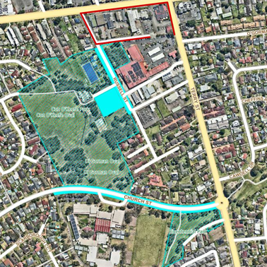
Blue (solid) - Existing Alcohol-Free Zone (AFZ)
Blue (striped) - Existing Alcohol-Prohibited Area (APA)
Red - Proposed additions to the AFZ or APA
What’s proposed:
- Re-establish the zone and extend boundaries to include Loftus Park.
Current zone includes:
- Wattle Reserve, all public land from Blackbutt Reserve to Carrington Street
- Wattle Road from Wallaroo Drive to Carrington Street
- Callistemon Place
- All laneways to Linum Place and Callistemon Place
- All footpaths within Lot 79 DP 700658
Proposed addition:
- Loftus Park
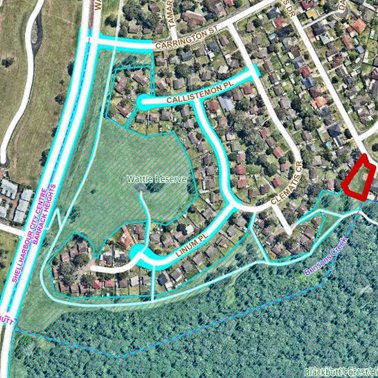
Blue (solid) - Existing Alcohol-Free Zone (AFZ)
Blue (striped) - Existing Alcohol-Prohibited Area (APA)
Red - Proposed additions to the AFZ or APA
What’s proposed:
- Re-establish the existing zone and extend the boundary.
Current zone includes:
- George Street from Shellharbour Road to Osborne Parade
- Beverley Park from George Street to Woodford Avenue
- Carpark west of Beverley Avenue
- Hall Lane, Spanish Lane, Shacklock Lane, McKeon Lane
- Susan Avenue
- Joan Avenue from George Street to Woodford Avenue
- Arcadia Street, Sparta Street, Terry Avenue, Brian Avenue
- Shellharbour Road from Terry Avenue to Woodford Avenue
Proposed addition:
- Carpark at 2 Terry Avenue
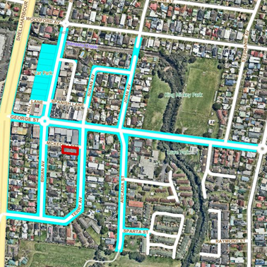
Blue (solid) - Existing Alcohol-Free Zone (AFZ)
Blue (striped) - Existing Alcohol-Prohibited Area (APA)
Red - Proposed additions to the AFZ or APA
Proposed new zones
What’s proposed:
- Introduce a new Alcohol Free Zone and an Alcohol Prohibited Area
Proposed zone includes:
- Rotary Park, either side of Princes Highway
- Station Street, adjacent to park
- Road reserve and footpath on the northern side of Princes Highway
- Creamery Road from Princes Highway, adjacent to the carpark
- Carpark behind shops adjacent to Creamery Road
- Hobart Lane
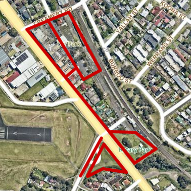
Red - Proposed new AFZ or APA
What’s proposed:
- Introduce a new Alcohol Prohibited Area
Proposed zone includes:
- Andrew Park
- Jones Park
- Reserve 6 (south of Jones Avenue shops)
- Reserve 7 (north of Jones Avenue shops)
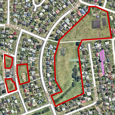
Red - Proposed new AFZ or APA
What’s proposed:
- Introduce a new Alcohol Free Zone
Proposed zone includes:
- Central Avenue from Hopetoun Street to Deakin Street
- Ayers Lane
- Reynolds Lane
- Wentworth Street from Central Avenue to Ayers Lane
- Griffiths Street from Reynolds Lane to Ayers Lane
- Kingston Street from Reynolds Lane to Ayers Lane, and adjacent to Fisher Street carpark
- Fisher Street from Reynolds Lane to Ayers Lane, and adjacent to Fisher Street carpark
- Hopetoun Street from Reynolds Lane to Ayers Lane
- Carpark adjacent to Ayers Lane, between Fisher Street and King Street (Fisher Street carpark)
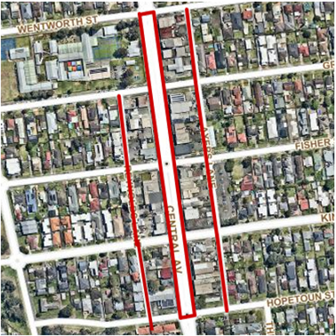
Red - Proposed new AFZ or APA


