About the Project
Council is making Terry Street, Wiley Street, and Hughes Drive safer for everyone. This work is funded through the NSW Government’s Towards Zero – Safer Roads Program. Over the past few years, more than a dozen crashes happened in a short section of Terry Street.
The upgrades will:
- Improve safety for drivers and pedestrians
- Make crossings and paths accessible for people with disabilities
- Improve traffic flow around the shopping centre
What's included in the project:
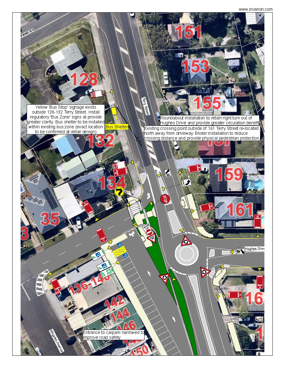
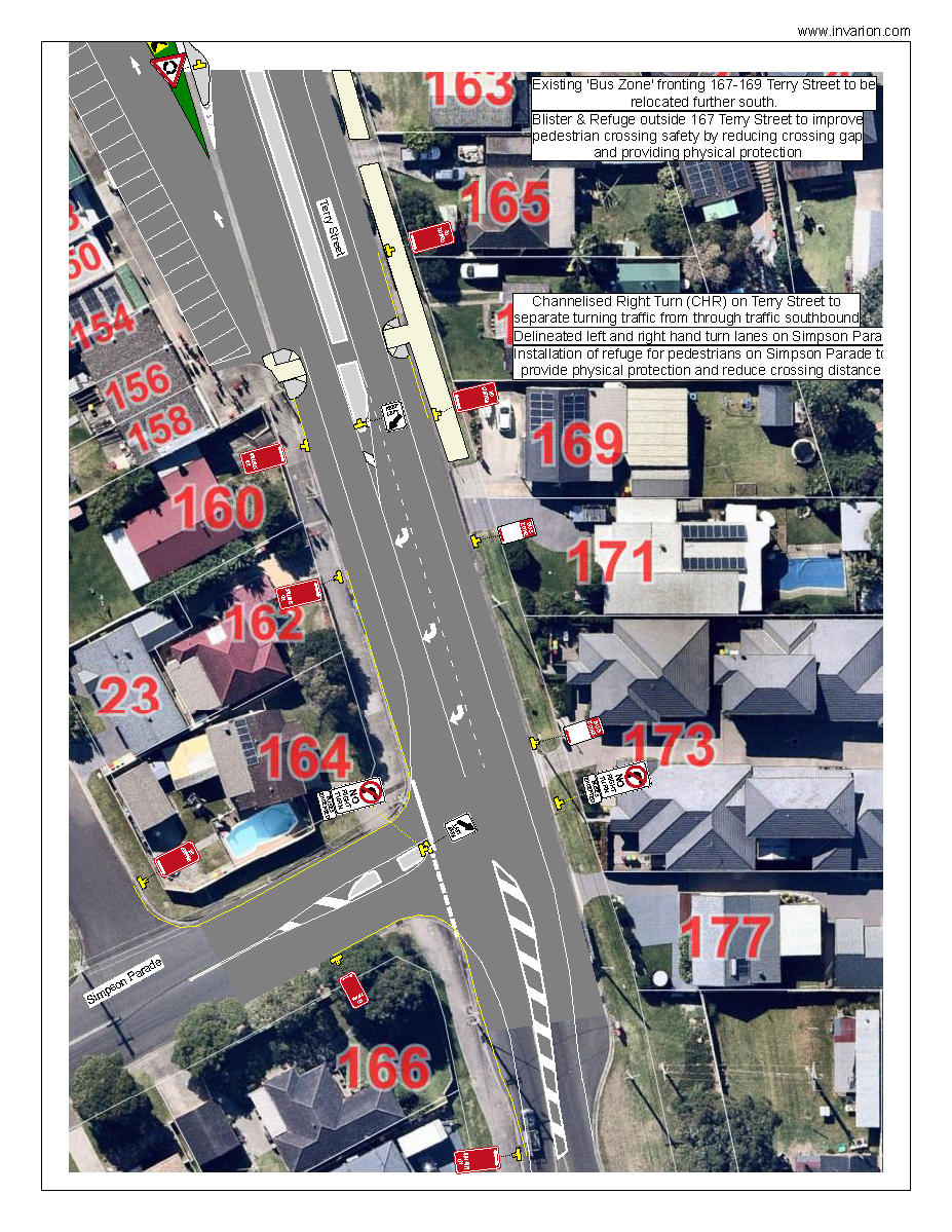
- The installation of a roundabout at T-intersection of Terry Street and Hughes Drive
- Implementation of one-way traffic flow within the shopping car park
- Installation of a raised pedestrian crossing at Wiley Street
- Accessible paths, ramps, and shared-use links for pedestrians
- Installing shared use path links to each of the upgraded crossing points
- Implementing left turn only on some side roads
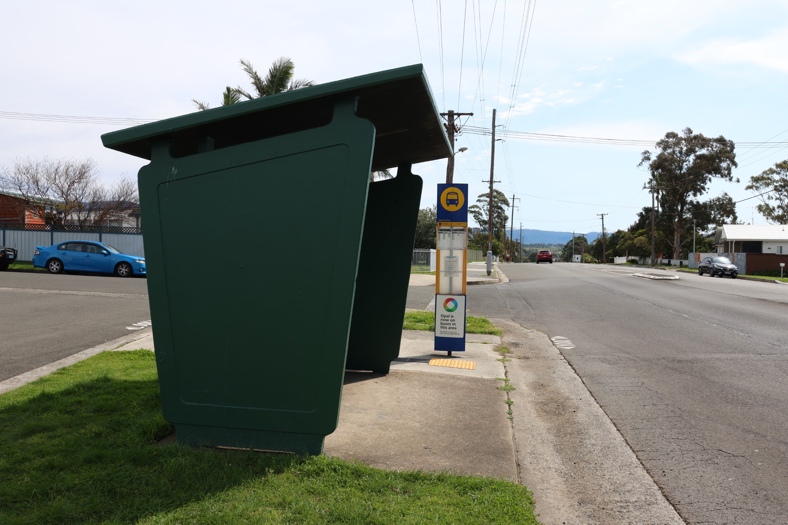
- Relocating the existing bus shelter
Design
FAQ
Construction FAQs
Construction will begin on 15 September 2025 and is expected to finish by the end of October 2025 (weather permitting).
To help keep things moving smoothly, construction will be completed in stages, as shown below, to minimise disruption to traffic.
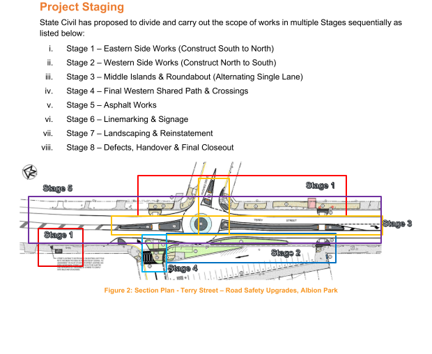
Construction is planned to commence on Monday 15 September and is expected to be completed by the end of October (weather permitting).
Construction will take place between the hours of 7am – 5pm, Monday to Friday.
There may be some night work for critical activities like concrete pours and asphalt resurfacing. Residents will be notified of any night work in advance by the contractor.
State Civil will be carrying out all works on this project.
Remondis will continue their regular schedule, but if your bin is missed, just give them a call on 1300 121 344 and they’ll arrange another collection.
Yes, you can still access the shops. The shopping centre car park will remain open, with one-way traffic in place, and loading dock access will also be maintained.
Street parking is available nearby. Please note that contractor vehicles will not be using customer parking spaces.
Traffic on Terry Street will remain open at all times, and there are no planned detours. Traffic management will be in place to guide drivers safely through the work zone. Some delays may occur, and we appreciate your patience.
If you want to avoid the area:
- Westbound travel: Use Hillside Drive to Church Street, then join Tongarra Road.
- Eastbound travel: Use Ashburton Drive to the East West Link.
- Northbound (towards Wollongong/Sydney) or southbound (towards Jamberoo): There are no alternative routes.
Yes, you will have normal access to your driveway. If any property is going to be affected, they will be contacted directly before work commences.
Project FAQs
Terry Street, between Wiley Street and Simpson Parade in Albion Park, has experienced several crashes and near misses. To improve safety for drivers and pedestrians, Council secured funding under the 2021/22 NSW Road Safety Program to carry out targeted upgrades.
The project focuses on enhancing safety at the intersection of Terry Street and Hughes Drive, a key route connecting Jamberoo and Albion Park. It also addresses areas with high pedestrian activity, including the local business centre, by improving accessibility, pedestrian safety, and traffic flow. These upgrades will benefit residents, businesses, and visitors alike.
To control traffic into the shops, and subsequently improve road safety in the area, a physical median has been installed to remove the right turn into the shop car park. The roundabout at the intersection of Smith Avenue/Terry Street can be utilised for traffic wishing to use the shopping centre car park from the north.
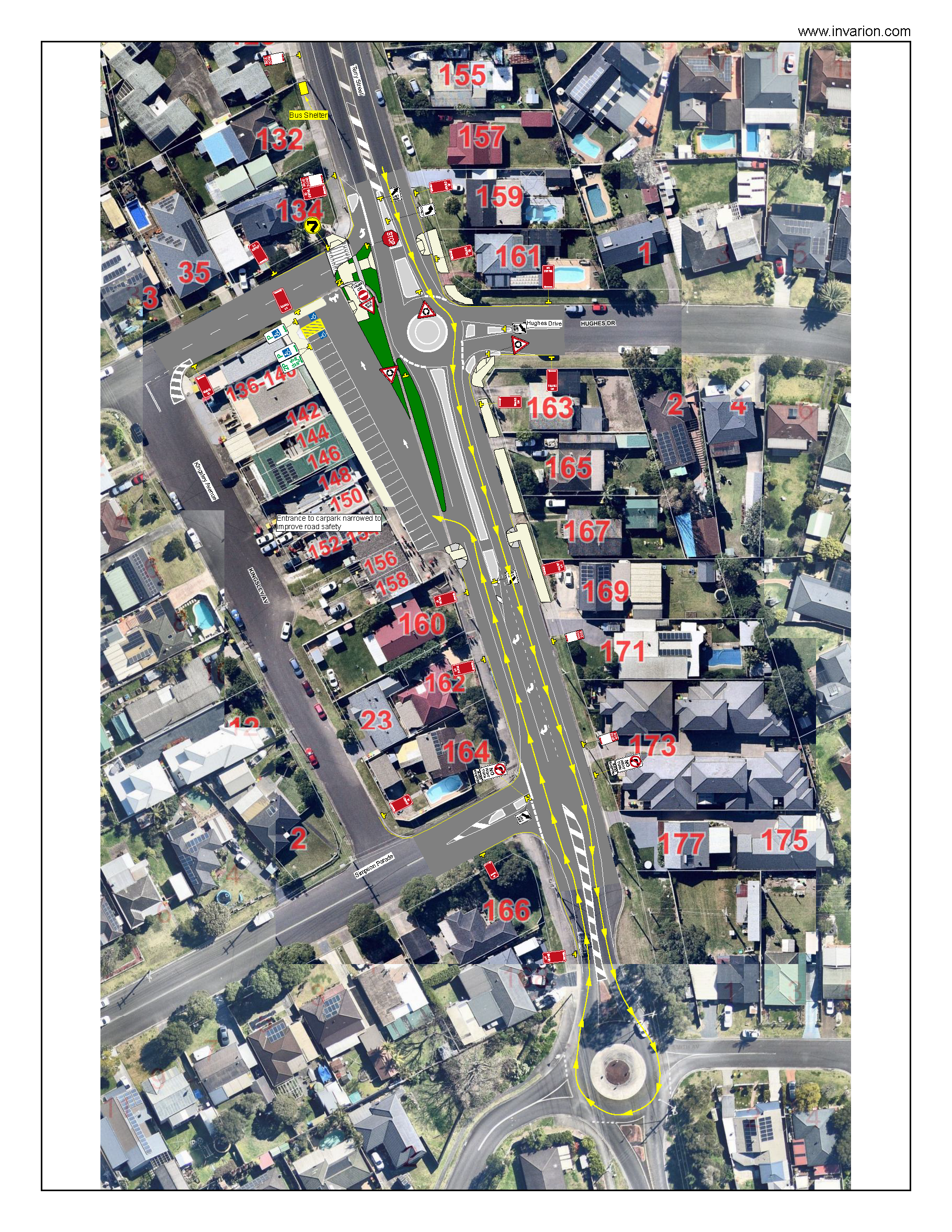
Figure 2: Access to shops from the north
Yes, there will be permanent changes as part of the new design.
As part of these upgrades, several on-street parking spaces along Terry Street and Wiley Street will be removed. Council has aimed to minimise the impact, but the installation of the roundabout, traffic blisters, and wombat crossings means some spaces will be lost. This is to ensure compliance with pedestrian 'sight distance' requirements, manage vehicular queue lengths, and make way for the upgrades.
Yes, the bus stop at the corner of Terry Street and Wiley Street (Stop 76/77) will be moved at the start of construction due to the roundabout installation. Its new permanent location will be about 60 metres north.
A new bus shelter will be installed at the new stop, and the existing shelter will be removed. The bus stop will remain fully operational, and Premier are aware of the change.
Previous Feedback
This project has been developed in consultation with the community since 2021 and has gone through multiple stages of feedback.
Across the life of this project we have:
- Asked for your feedback on the design and subsequent changes two times.
- Received 107 contributions from the community.
- Spoken with business owners and residents directly.
- Had 1,214 visitors to this page.
Ask our Transport Team
Thank you for your questions. The Transport team members will respond by close of business 7 October 2021.
To ask a question you must create an account or log in.
These are the people that are listening and responding to your questions.

Transport Team
Council’s Transport team welcome all questions and feedback which may be used to improve the upgrade during the detail design phase. Answering your questions will be:
- Wayne Wilson (Senior Transport Engineer)
- Tyson Perry (Engineering Technical Officer)
- Jenny Davies (Road Safety Officer)
{{question.description}}
Previous concept designs

Figure 4: Alternative routes to travel north and south on


